


IRRIGATION CANALS
What happened to them?
The name Irricana was derived from the words irrigation and canals. Although it isn’t apparent today, the farming area around Irricana was once intended to be a significant user of irrigation technology. At least as it existed at the time.

Construction of the local irrigation system began in 1903 and was preceded by 8 years of survey and planning. It was part of the 3 million-acre “Irrigation Block” between Calgary and Medicine Hat developed for irrigation by the CPR. This land had been granted to the railway company in 1881 with a condition that it should be fit for settlement. Frequent dry years did not favor settlement so irrigation was required. Most of this territory had previously been leased to ranchers for livestock grazing. Almost no settlement had taken place.
In 1894 the federal government passed the Northwest Irrigation Act and the transformation of this part of the Canadian prairies began. For easier administration the CPR divided its huge block of land (125 miles long and 50 miles wide) into three equal sized sections: western, central and eastern.

Development of the western section began first and was completed by 1911. It included 16 miles of main canal and 2,480 miles of secondary canals and laterals. The total cost was approximately $4,827,000. This was a huge construction project involving hundreds of laborers, horses and equipment.
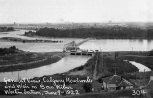
The main canal took water from the Bow River downstream from St. George’s Island in Calgary and delivered it to Reservoir No. 1 at Kinniburgh Slough (Chestermere Lake). From this reservoir the secondary canals delivered water to the north and the east. The system located west of Irricana extended almost as far north as where Highway 72 is today. It included an 1800-foot syphon that carried water across the Crossfield Creek from west to east. A CPR farm was established 4 miles west of Irricana where irrigation workers who maintained the canals lived. This was intended to be a demonstration farm to give advice to new water users in the area.
The CPR initiated an aggressive campaign to sell the land as it was developed for irrigation. In 1908 and 1909 four hundred thousand acres were sold to new homesteaders. Land that was eligible for irrigation sold at a premium price of $30 per acre compared to dryland at $13.
Unfortunately, it was discovered that the area west of Kathyrn and Irricana wasn’t suitable for irrigation due to high contents of sand and gravel in the soil and subsoil (evidence of this feature is the gravel mining that has taken place from north of Keoma to west of Beiseker). This section of the irrigation project was abandoned, and the Crossfield syphon was demolished (some remnants of the original canals are still visible today). The total irrigable area in the Western section was reduced by 30 percent following a government survey and reclassification in 1913 to 1915. This was because of issues with soil alkalinity.
Some of the canals to the west continued to supply water to natural watercourses including Carleton Creek, Crossfield Creek and the Rosebud River. Sullivan slough south of Irricana is part of this system. Salt Lake (a mile east of Irricana) is also supplemented by irrigation waters.
By 1940 the CPR intended to disband its irrigation project and in 1944 the Western Irrigation District was formed by local farmers to take over the western system. Since then, government funding and other arrangements have been used to upgrade the irrigation system and modern technology developments have enabled users to irrigate their crops more efficiently.
FURTHER INFORMATION:
https://www.youtube.com/playlist?list=PLAC4D1E62F9C99F8F
SOURCES:
KIK COUNTRY, K.I.K Historical Committee, 1974
ACRES AND EMPIRES - A HISTORY OF THE MUNICIPAL DISTRICT OF ROCKY VIEW, Tracey Read
https://electricscotland.com/history/canada/alberta/vol1chap20.htm
https://www.canadiancattlemen.ca/our-history/railways-and-irrigation/
